The Emerald City in the Gutter
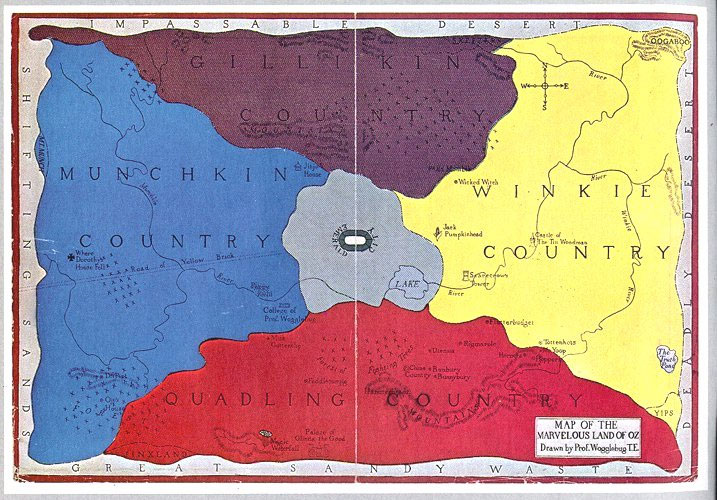
One difference is that this is a later reprinting of the map that first appeared in Tik-Tok of Oz (1914). As David discussed, the compass rose originally put east on the left and west on the right, contrary to the usual approach. At some point in subsequent decades, the publisher changed the labels so “E” was on the right as usual.
Of course, that change also meant the map showed the Winkie Country to be east of the Emerald City instead of west, as all of L. Frank Baum’s books described it. But his successors Ruth Plumly Thompson and John R. Neill started to state that the Winkies lived to the east, conforming to the reprinted map and its conventional compass.
Another difference is that the version of the map above is a broadside while the image David showed was scanned from an early copy of Tik-Tok of Oz, where it served as the endpapers. And that highlights a feature I find really interesting from the perspective of book design.
This map had to look good both as endpapers, when a thin strip of its middle would be concealed in the book’s binding, and as a poster or broadside lying flat. The artist accomplished that by making sure that almost no sites and no lettering fell within that central strip. Some large labels bridge the strip, such as the word “GILLIKIN” in the top quadrant—but there’s a little extra space between the second I and the K that could disappear into the binding.
The Emerald City was a challenge because Baum was clear that it’s in the middle of Oz—and thus in the middle of this map. How to keep it from vanishing into the gutter? The artist’s solution was to depict the city as a horizontal oval, with the word “Emerald” on the left and “City” on the right. (David Hulan once pointed out that the oval approximates an “emerald cut” in jewelry.) Then when the central strip of the map is hidden (look back on David’s map), the city appears as a circle and its full name remains legible.
On the accompanying map of Oz and surrounding countries, shown below, the Emerald City is safely off-center. And it appears as a circle, as it would appear in the endpapers form of the Oz map. This time the artist tried to keep other labels and locations out of the central strip. In the image from Wikipedia below, you can see where that got tough.

![]()


No comments:
Post a Comment